The Lime Kiln is a very nice and relatively unused trail in
Birds Hill Park. It can be a tricky path to follow with its more
than forty crossings. It's a 7.5 km round trip starting at the
Birds Hill Park Ranch parking lot. The trail is wide and flat with
a surface of packed dirt in the front and grass covered in the
back. The elevation ranges from 265 metres at the trail head to 240
m at the Lime Kiln. This mostly forested path has some nice
features along the way including sand pits, earthen mounds and of
course the Lime Kiln. There is a warm up shack half way around the
trail with a vault toilet. The trail is designated for hiking and
horses in summer and cross country skiing in winter. No hiking
or dogs are permitted on the groomed cross-country trails in the
winter. There are washrooms, a pay phone, restaurant and
stables at the trailhead.
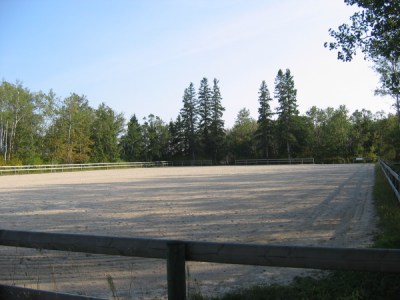
Located near a sand ring in the forest surrounded by a rail
fence. I thought this was called a corral so the logbook, FTF and
label all say Corral. It seems every trail in this part of the park
converges here! The container is a winter friendly, dark green, 750
ml Lock and Lock hidden just a few paces off the trail in some
light bush. Take the Grand Prix Hunter Ring path.

Trail maps:
Birds Hill Provincial Park
Save the following ZIP file containing a GPX track of
the trail to load on your GPS:
Lime
Kiln Trail GPX file

|
Additional Hints Hints
Current at 11/6/2011
 9/13/2009 by Kabuthunk
Man, it wasn't that easy for me to find any caches at the park today. I think fate was trying it's damnedest to make it as difficult as possible  . The day started out quite nice though. I parked at the "lake", swam for a bit, then biked over to these caches to air-dry (but all the biking was also followed by MORE swimming, so it's all good
  ). Thus, after the aformentioned swimming, I worked my way towards the coordinates.
I started out the day attempting to get the LKST-1a Cookout cache (of which on my GPS I didn't have the full name, which is probably why I was confused several minutes later), but when I got to about 80 meters from the coordinates, I started hearing... sounds. Voices, children, what sounded like the crackling of a fire. What the hell?!? Being completely unfamiliar with all of the various things in the park, I was rather surprised to hear anything, since as far as I knew, pretty much anything North of the main roads was all trails, and otherwise just straight wilderness. However, once I got to around 30 meters away, I spotted what appeared to be a vehicle (which brought to my mind the question "how in the hell did it even get IN this deep"), and I could definitely confirm the voices of a family of at least 4 people in the midst. Given my GPS was telling me to pretty much go DIRECTLY towards them, I opted instead to abandon that attempt. Onwards!
Checking the GPS, there was either one further East (which ended up being either just past or near a large building and area with many horses... I must have just managed to pick a day when some stupid event was happening... so I had to abandon that one on the way back), or this one to the North. Feeling somewhat defeated before even attempting at the Cookout cache, Northward I biked! Although, it could have been a lot more pleasant. Given the abundance of horses that seemed to be around today, the trail ground was chopped up and bumpy as hell from the horse hooves  . Smelling horse-crap and rough biking conditions. Great . However, once I got past the rougher part, which I assume got that way due to wetter ground or something, it was smooth sailing again. A few twists and turns, and... what's this? I found myself at a large, empty area (the assumed Corral... that part of the name was cut off on my GPS, so at this point I still had no clue that any of this was horse-related, aside from the hoof-marks in the ground, but those are all over the park, and I've always attributed it to people with horses living nearby). Since someone was working in this area, I avoided them and hunted for the cache. It didn't take long before I was successful . At least this trip through the forest was a lot better than other forest adventures through the park . But holy hell, were the mosquitoes insane! I had to take the logbook, and attempt to sign it while walking around in the more open part of the trail... which didn't actually help at all . Those bloodthirsty buggers FOLLOW you! At a good clip! I only lost the swarm that was around me when I got back onto my bike!
But... I was indeed successful, and aside from the roughness of the trail, it was fairly pleasant. I wasn't actually aware that all of the intersections in here were all part of one, longer, looping trail though. I'm going to have to take a day to do the full circuit sometime. Although, it definitely explains the "Finish" pseudo-sign that I noticed when I was heading back towards the "lake" . Unfortunately, I forgot to drop a TB in that I was planning to, but that found its way into another cache in the park anyway  .
.
So thanks for the ride, and I'll have to check out this Lime Kiln that all your cache descriptions speak of sometime.
Took: Nothing
Left: Logbook entry and chainmail ball
Nearby Caches
GC1X2CW  LKST-1a Cookout (0.48 kms S)
GC1X2BA LKST-1v2 Looking for a Sign (0.48 kms S)
GC12YTV Overlook Splash Cache (0.94 kms S)
GC1HTTY Deer Trail (0.96 kms E)
GC12N38 A Little Splash of Murder (0.99 kms S)
GC12M42 ROCK HILL (1.39 kms E)
GC1GTZY 303 Pathfinders (1.40 kms SE)
GC15X34 Cedar Grove 2 (1.47 kms SW)
Hints (Back)
Hanging about waist high from a baby oak tree by a couple of other young oaks
 LKST-10 Ring (Corral) by TurdleEggs (2/2.5) (Archived)
 Small Hidden on 9/28/2008
 Terrain:


