GC12TPF Earthcache Manitoba Tyndall Stone
Type: Earth | Size: Not chosen Not chosen | Difficulty: 3 out of 5 | Terrain: 1 out of 5
By: junglehair @ | Hide Date: 10/05/2007 | Status: Available
Country: Canada | State: Manitoba
Coordinates: N49° 53.303 W97° 08.079 | Last updated: 10/06/2026 | Fav points: 0
Available at all times  Available during winter  Wheelchair accessible  Bicycles 

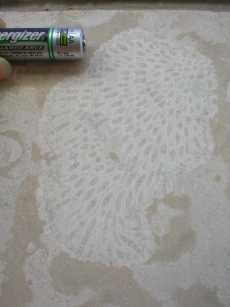
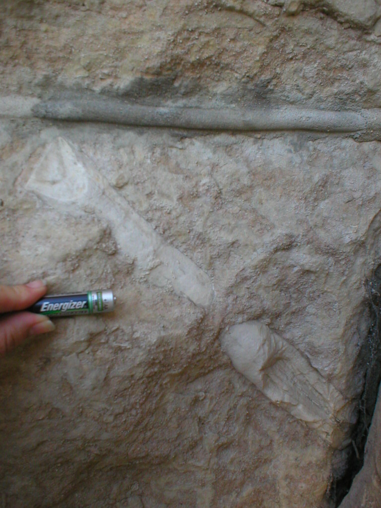
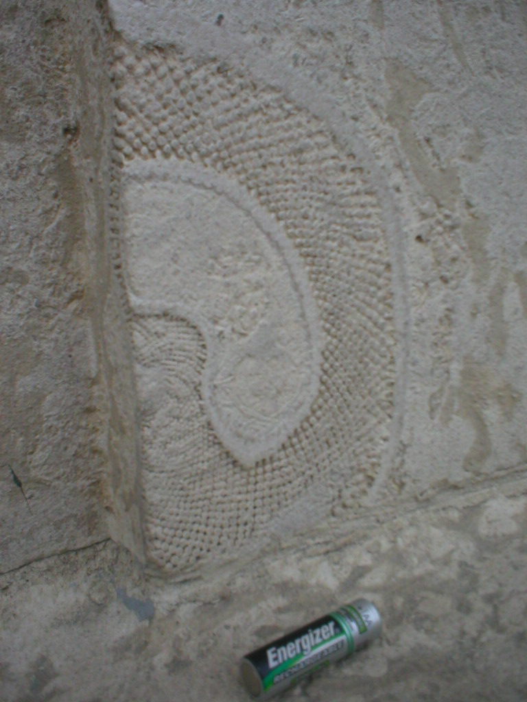
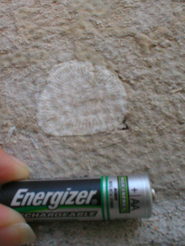
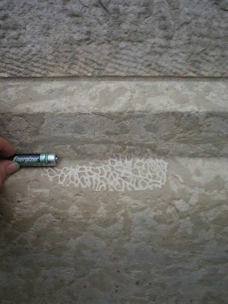
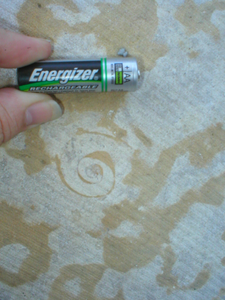
This is an EarthCache located in Downtown Winnipeg. It is wheelchair accessible. All fossils can be found on the exterior of the buildings no more than 2 meters above ground. NOTE: The accuracy on your GPS will be low in these areas due to the obstruction of the buildings. Be prepared to search a wider area than usual.

Tyndall Stone is used as an ornamental building stone in many cities in Canada and the United States. It is a light brown, fossil bearing limestone that has darker coloured branching streaks called trace fossils. While there are many limestones used as building stone in North America, Tyndall Stone is unique.

The colour, beauty and strength of Tyndall Stone has allowed for its use in a variety of ways and architectural styles. Impressive buildings containing Tyndall Stone include the Parliament Buildings in Ottawa, the Canadian Museum of Civilization in Gatineau, the Provincial Legislature in Manitoba, the Rimrock Hotel in Banff, and the Empress Hotel in Victoria.

Tyndall Stone is quarried at Garson, Manitoba, about 40 km northeast of Winnipeg. It was first discovered in the area around 1894, when a farmer came upon the mottled limestone while digging a well. The first large quarry was opened by William Garson in 1898. Gillis Quarries Limited began quarrying there in 1915, and the fourth generation of this family-owned business is still at it today.

How Did Tyndall Stone Form?
Four hundred and fifty million years ago, what is now southern Manitoba was part of a warm, shallow, inland sea. During this time, which geologists call the Ordovician Period, this area was just south of the equator. Many different types of animals lived in this ocean. Some, such as corals, sponges, molluscs, and algae, we would recognize today. Others, such as trilobites and stromatoporoids, are extinct. All of these creatures lived on or above the soft, muddy sea floor. After they died, their remains became part of it. The calcium carbonate in their skeletons made the mud limey, so that when it hardened into rock it became limestone. Fossils of these animals and plants are visible today in Tyndall Stone.

Other animals burrowed in the mud of the sea floor for food or protection. And it is the preserved burrows of these creatures that make the beautiful mottling which gives Tyndall Stone its unique appearance. Nobody knows what exactly these animals were, because the traces of their burrows are all that they left behind. But shrimp in the Caribbean Sea make similar burrows today, so it's possible these creatures were shrimp-like.

Why are the burrows a different colour from the rest of the rock? Well, it all comes down to a difference in grain size and chemistry. As the animals burrowed through the soft, limey mud, they left traces of their passage that caused the mud in the tunnels to be slightly different from the surrounding sediment. The more tightly packed surrounding mud hardened before the less dense deposits in the burrows. Later, magnesium-rich waters percolated through the rock and deposited dolomite in the burrows, but couldn't penetrate the tightly cemented limestone rock. The darker colour of the burrows may be a result of oxidation of trace amounts of iron in the dolomite, or of pyrite that was deposited along with the dolomite.

The information listed above was copied from a publication by the PDAC.

Requirements

To log this EarthCache, you must match the fossil name, with the correct photo and the coordinates where that fossil was found.

Fossils Names:
Colonial Coral: Calapoecia
Receptaculitid: Fisherites (often cited as Green Algae)
Horn Coral
Gastropod
Cephalopod
Chain Coral

Coordinates:
N49° 53.318 W097° 08.708 (391 York - East Side)
N49° 53.366 W097° 07.342 (St. Boniface Cathedral)
N49° 53.180 W097° 08.209 (Fort Garry Place)
N49° 53.370 W097° 08.086 (North side of Union Station)
N49° 53.349 W097° 07.345 (St. Boniface Cathedral)
N49° 53.310 W097° 08.027 (South side of Union Station)

Photos:

Note: You can click on the photos to view a larger version.


Photo A

Photo B

Photo C

Photo D Alternate image

Photo E

Photo F


Complete the rest of this table, then email your answers to me using the profile link above.

Photo Name Coordinates
Photo A Colonial Coral: Calapoecia N49° 53.318   W097° 08.708
Photo B    
Photo C    
Photo D    
Photo E    
Photo F    


Special thanks to Jacques Bourgeois and Dr. Graham Young for their assistance in identifying some of the fossils. If I have made any errors, you can be certain they are my own.

This cache was created to add to the number of QUALITY caches hidden in Manitoba. It is an official cache in the MBGA Cache Splash event.
Category 34: Earth Cache.


junglehair has earned GSA's highest level:


EarthCache Supporter

Additional Waypoints

F112TPF - Wpt 1
N 49° 53.318 W 097° 08.708
Colonial Coral: Calapoecia
F212TPF - Wpt 2
N 49° 53.366 W 097° 07.342

F312TPF - Wpt 3
N 49° 53.180 W 097° 08.209

F412TPF - Wpt 4
N 49° 53.370 W 097° 08.086

F512TPF - Wpt 5
N 49° 53.349 W 097° 07.345

F612TPF - Wpt 6
N 49° 53.310 W 097° 08.027

 Custom URLs

Add cache to watch list
Log your visit
Picture Gallery

 Nearby Caches


 Logs

3 Logs: Found it 1  Write note 2  

Write note 17/06/2007 By Kabutroid
N49° 53.180 W97° 08.209
Wow, I wasn't aware that trilobites were so rare to find in this type of stone. Glad to have been the one to locate it BigSmile.

I've also re-visited the site to confirm it's exact location, and provide some pictures as to where it can be found. Basically, it's just to the left of the West-facing exit of the building located at N49° 53.180 W97° 08.209. See attached pictures for details.

Note: The trilobite is probably my favourite type of fossil, hence me going to such lengths to help others find it Smile.

Found it 14/06/2007 By Kabutroid
EDIT: The gracious Junglehair has allowed me to log this as a found, since I DID get all of the picture-identifications correct at least, and did visit all of the locations in question. Due however to a lack of working printer, or way of viewing images while at the cache site, the pictures that I snagged managed to not be the ones that were listed on the page. I've attached them regardless though, so you can now see OTHER fossils available at the various site locations.

However, I can honestly say that I never noticed that there were THIS many fossils in the sides of buildings. Sure, I've noticed one or two... but there's TONS of them! And on a random note: while I was at one of the cache sites, some guy in a wheelchair noticed me taking pictures of the fossils and told me there's a really detailed one of a snake (so he says... I'm thinking it might be one of the algae ones... forgot to double-back to it to check it out though) on the legislature building, near one of the entrances, between two planters. If you're at that building, you may want to look for it, if it's as detailed and large as this guy described.

But anyway... visiting all of the locations for this was quite the exercise. 27kms of biking, a sunburn, and a mild case of heatstroke later though, and I had a ton of pictures of all kinds of fossils, and got to see the archetecture of many an interesting building. Thanks for all the places to check out Junglehair Smile. As well, I passed by a park or two that I never knew existed. I think they even may have been thus far cache-less Shock. So it was a very interesting and busy day biking downtown. I've got to make a mental note to do it more often.

When it's cloudy, or I remember to put on sunscreen. Or both ToungeOut.

Strangely, it appears that with an earthcache, you're unable to drop a travelbug such as a personal TB into it. Peculiar. I'll have to just make a note in the personal TB log for the last cache for this one.

But once again, thanks for letting me log the find, and showing me the multitude of fossils strewn throughout the city. I'll definitely be keeping my eyes open for them more often from now on BigSmile.

Took: A ton of pictures
Left: Nothing but faint bike-tire tracks on the sidewalk (and hey, the pictures contain a chainmail ball) ToungeOut

[This entry was edited by Kabuthunk on Friday, June 15, 2007 at 1:12:40 PM.]

Write note 05/06/2007 By Kabutroid
Blargg. Didn't realize at first how much work was behind this cache. I wandered over here with my fiancee today, and cracked open my palm pilot to see what the logging requirements were. Evidently, taking pictures. I have a camera, no problem. Cachemate doesn't do pictures, so I'd have to compare 'em when I got home. However, after putting in the first set of coords in my GPS, it indicated the first stop was something like 900 meters away. At that point, we said 'nuts to it for today' and wandered back to the Forks where we parked.

I'll finish claiming this one another time, but I'll likely have to be on my bike, and have all the coords pre-punched into my GPS to make it faster. I get the feeling I'll be getting my exercise the day I plan to complete this one ToungeOut.